
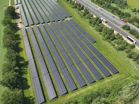
RPS analysis for PV systems near federal highways
Proof of whether the module tables, stations, fence and gates of a ground-mounted system maintain the critical distances to the motorway or federal road according to RPS 2009 and ARS 26/2024.
Background
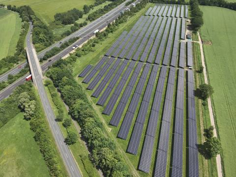
If a planned ground-mounted photovoltaic system borders a federal trunk road – i.e. a federal motorway (Bundesautobahn) or a federal road (Bundesstraße) – the competent road authority or the FBA (Federal Highway Authority, Fernstraßen-Bundesamt) may require proof in the permitting procedure: do module tables, stations, fences and gates keep a sufficient distance from the carriageway so that they do not pose an additional risk if a vehicle leaves the road?
The basis is RPS 2009 (German guidelines for passive protection on roads by vehicle restraint systems, Richtlinie für passiven Schutz an Straßen durch Fahrzeug-Rückhaltesysteme). It classifies obstacles into hazard levels and from these defines the critical distances A and AE to the outer edge of the carriageway.
Since the Allgemeines Rundschreiben Straßenbau No. 26/2024 (ARS 26/2024, general road construction circular of the Federal Ministry of Transport), photovoltaic areas are to be assigned to hazard level 1 and therefore assessed using the extended critical distance AE. Analyses that still argue without ARS 26/2024 no longer reflect the applicable rules.
| Object | Classification | Distance |
|---|---|---|
| Module tables | PV area, hazard level 1 according to ARS 26/2024 | AE |
| Stations | Transformer, inverter and grid connection stations, treated together with the module tables as PV area | AE |
| Battery storage | Classified like stations, as part of the PV area | AE |
| Gates | Gate posts in cast-in-place concrete foundations: non-deformable individual obstacles, hazard level 3 | A |
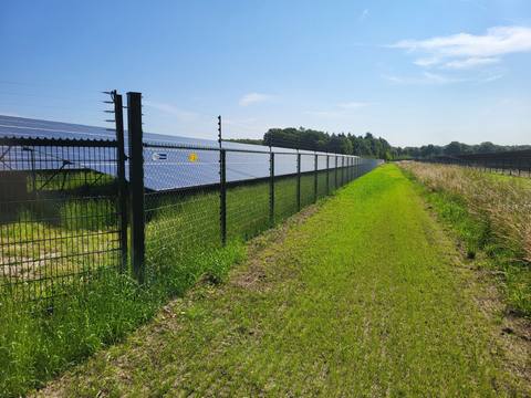
| Fence, conventional design (double-wire mesh panel) | still deformable, but not traversable, hazard level 4; separate obstacle alongside the PV area | A |
| Fence, demonstrably traversable | slender posts without a solid base or foundation: not an obstacle within the meaning of the guideline | – |
| Existing buildings | are included in the evaluation so that the statement applies to the entire study area | depending on classification |
Basis: RPS 2009 Section 3.3, ARS 26/2024. Existing vehicle restraint systems and raised ground between the carriageway and the system are explicitly identified in the report.
What determines the required distance
Three factors are decisive:
- Hazard level of the object. It determines whether A or AE applies. Under ARS 26/2024, module tables and stations are assigned to hazard level 1 and assessed using AE.
- Maximum permitted speed on the road section concerned, with the threshold at 100 km/h.
- Height difference between the edge of the carriageway and the ground surface at the hazard location. If the system lies higher or lower than the carriageway, this shifts the required distance.
The distance is measured from the outer edge of the paved carriageway. On federal motorways this may include the hard shoulder, which shifts the reference line by several metres; according to the FBA document, acceleration and deceleration lanes and junctions are also part of the paved carriageway.
| Maximum permitted speed | A | AE |
|---|---|---|
| above 100 km/h | 12.0 m | 20.0 m |
| 80 to 100 km/h | 7.5 m | 11.5 m |
| 60 to 70 km/h | 4.5 m | 7.5 m |
Source: RPS 2009 Figures 2 to 4. Distance from the outer edge of the carriageway, ground at carriageway level. For motorways and motorway-like roads, the values in the first row also apply at speeds of 100 km/h or less.
| Ground relative to the edge of the carriageway | A | AE |
|---|---|---|
| 3 m or more higher | 7.5 m | 15.5 m |
| same height | 12.0 m | 20.0 m |
| 10 m lower | 27.0 m | 35.0 m |
Source: RPS 2009 Figure 2. Intermediate values linear.
Procedure
| Step | Content |
|---|---|
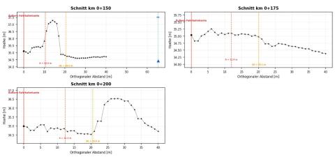
| 1. Observation points | Parallel offset lines are created from the outer edge of the carriageway at one-metre intervals up to 40 m. An observation point is set every 25 m along the road and a cross-section is taken perpendicular to the road alignment. |
| 2. Distances A and AE | At each observation point, the height difference between the edge of the carriageway and the ground surface is evaluated. Together with the maximum permitted speed, this gives A and AE – point by point, not as a single value for the whole system. |
| 3. Comparison with the objects | Each object is assigned to one of the two distances according to its hazard level. The values of all observation points form the boundary line against which the check is made. Where an object lies within the distance applicable to it, the report quantifies how far it needs to be moved. |
Data basis
We work with the client's plans, official elevation data (DGM1 digital terrain model of the state survey office, height reference NHN) and current aerial images. The origin and date of all data used are stated in the report – as are all assumptions relevant to the result, for example on the maximum speed, the fence line or existing restraint systems, so that the authority can check them.
Result: report and geometry file
Verifiable report
Summary of the results, derivation of the critical distances, preliminary topographic review and evaluation across the observation points. The decisive critical distance is derived and quantified and the determined minimum distance is stated; with a clear reference to the plans and a statement of validity for later system variants.
Georeferenced geometry file
The required minimum distance to the federal trunk road as a shapefile or georeferenced DXF. The file can be loaded directly into GIS or CAD without transferring dimensions from a PDF; a revised system layout can be checked against the boundary immediately.
Quality assurance
Each analysis is prepared by one expert and reviewed by a second.
Language
We prepare the analysis in German or in English.
Frequently asked questions
When is an RPS analysis required?
If a ground-mounted system borders a federal trunk road – i.e. a federal motorway (Bundesautobahn) or a federal road (Bundesstraße) – the competent road authority or the Federal Highway Authority (Fernstraßen-Bundesamt, FBA) may require proof of the distances to be maintained in the permitting procedure. Whether proof is required depends on the individual case and on the competent body. The analysis is useful whenever module tables or stations come close to the critical distance.
What is the difference between A and AE?
RPS 2009 defines two critical distances to the outer edge of the carriageway: the critical distance A and the extended critical distance AE. Which one applies depends on the hazard level of the object. Since ARS 26/2024, the extended distance AE has been decisive for photovoltaic areas. It lies considerably further from the carriageway than A.
Does the fence count as an obstacle?
As a rule, yes. Conventional fences made of double-wire mesh panels are still deformable, but not traversable: they are assigned to hazard level 4 and must maintain the critical distance A. A fence is only considered traversable, and therefore not an obstacle, if this has been demonstrated – slender posts without a solid base or foundation (RPS 2009, Section 3.3). Gate posts in cast-in-place concrete foundations are non-deformable individual obstacles. We therefore ask for the fence system and the post foundations in advance.
What has changed with ARS 26/2024?
The Allgemeines Rundschreiben Straßenbau No. 26/2024 (general road construction circular of the Federal Ministry of Transport) assigns photovoltaic areas to hazard level 1. They are therefore to be assessed using the extended critical distance AE. Analyses that still argue without ARS 26/2024 no longer reflect the applicable rules.
From what distance is no proof required?
According to the document of the Federal Highway Authority on photovoltaic systems (as of 01/2025), proof is generally not required at a distance of more than 40 m from the edge of the paved carriageway. Irrespective of this, the building prohibition zone (40 m) and the building restriction zone (100 m) apply along federal motorways; the FBA decides on what is permissible there.
What do I receive at the end?
Two results: the verifiable report with the derivation of the critical distances, a preliminary topographic review and the evaluation across the observation points – and a georeferenced geometry file of the required minimum distance as a shapefile or DXF. The file can be loaded directly into GIS or CAD; a revised system layout can be checked against the boundary immediately.
How long does an RPS analysis take?
Usually two to three weeks after receipt of complete documents. If it is urgent, please contact us.
Enquiry
Use the form, call us on +49 4103 121 4221 or write to kontakt@sonnwinn.de – whichever suits you best.
You do not need to attach documents to your enquiry – once we have received it, we will help you put together the documents required.
Which documents are helpful
- Site plan of the system with module tables, stations, fence, gates and access roads, preferably as DWG or KML
- Data sheet of fence and gates: fence system and post foundations (driven or set in concrete)
- Information on planned earthworks on the PV area, such as fill, excavation or embankments
- If available: statements from the authority, e.g. the Federal Highway Authority or Autobahn GmbH